English


Target audience
MaPagenda is a productivity tool for companies that have to manage the routes of their roaming personnel in order to optimize the kilometric costs and to minimize the unproductive time that the personnel spend on the roads.
- Typology of targeted occupations:
- Maintenance of equipment under maintenance contract
- Commercial with pre-defined tours
- Health and personal services
- Etc.
- Lexicon used:
- Point of interest: the address of the appointment, the point on the map
- The traveler: a salesman, technician who has to go to a point of interest
How MaPagenda Works
The MaPagenda component receives from its host database a structured selection of points of interest (boiler to be reviewed, person to be cared for, package to be delivered …) and displays them at the same time:
- In a detailed list
- On a map adjusted to the area of the tour.
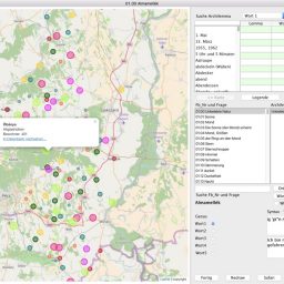
The list
Seen from the list, points of interest can be grouped in this way:
- A traveler and several days of points of interest
- Several travelers and a day of points of interest
- In addition the list is sorted by appointment order and displays:
- The meeting time,
- Time and mileage to go to next appointment
- The name or code of the point of interest
- The address of the point of interest
- An icon indicating a geolocation error or an update of the coordinates
Note: it is possible and advisable to send GPS coordinates in addition to the address of the appointment. MaPagenda helps you to geolocate each of your points of interest
A click in the list shows on the map:
- Single point of interest: Click on a time of appointment
- The tour of the day for the traveler: click on the name of the traveler
The map
Seen from the map, the markers of each of the points of interest are identified by an order number and a “bird’s eye” path reads them together: the inconsistencies are instantly observed and quickly corrected.
Each marker can be identified by a color specified by its status.
The main features:
A horizontal presentation and a vertical presentation
- Map in consultation mode or Interactive mode
- View mode
- The host application sends the data and the map displays
- Interactive mode
- The host application sends the data and points of interest can be changed and the host application is notified.
- Points of interest have a status and an associated color
- Points of interest are numbered
- Points of interest are connected by a “bird’s eye” path
Communication with the host application:
- New GPS coordinates after repositioning a marker
- Create GPS coordinates after adding a marker
- Cumulative times and kilometers after repositioning a marker
- Call recording on marker click
- Send sum of times and kilometers after internal calculation
Export GPS coordinates of points of interest to GPS equipment garmin
Availability of APIs to obtain:
- GPS coordinates
- Calculate a distance between two points
MaPagenda uses both Google and OpenStreetmap services.